THE RIM

Rauth Crossing

Rauth Crossing / Town plan30 NAMED ROUTES · 26 PLACES
100%
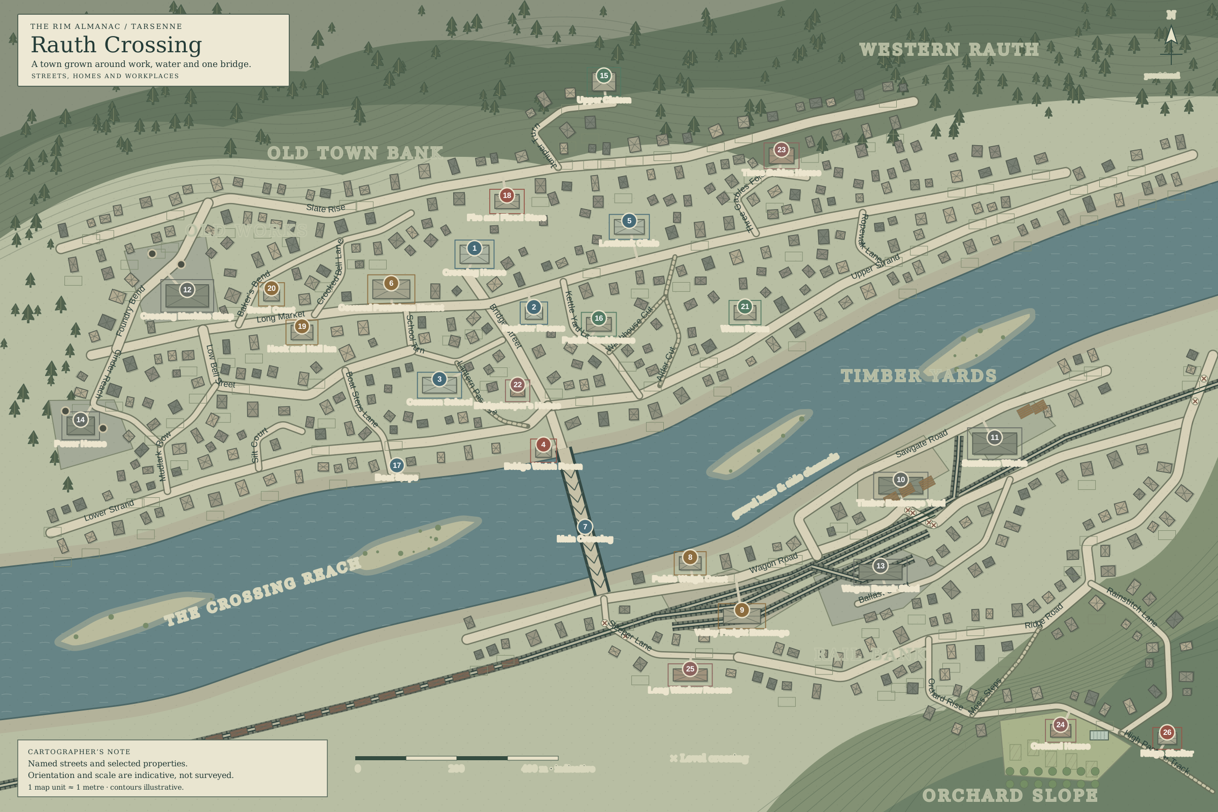
Rauth Crossing: town planA top-down plan of Rauth Crossing: thirty named streets and paths, twenty-six landmarks, mixed homes and works, a winding river, one principal truss bridge, freight sidings and forested slopes. Orientation and scale are indicative. Use the accompanying directory for descriptions.Wagon Road: marked level crossingWagon Road: marked level crossingSleeper Lane: marked level crossingRidge Road: marked level crossingOLD TOWN BANKRAIL BANKOLD WORKSTIMBER YARDSORCHARD SLOPEWESTERN RAUTHTHE CROSSING REACHgravel bars & side channelsBridge StreetLong MarketCrooked Bell LaneSlate RiseSchool TurnLow Bell StreetUpper StrandLower StrandBoat Steps LaneMudlark RowAlder CutSilt CourtWagon RoadSleeper LaneSawgate RoadCinder ReachFoundry BendBallast StreetRidge RoadOrchard RiseRainstitch LaneMoss StepsJuniper TurnHigh Pasture TrackLantern PassageKettle Yard LaneThree Gables FoldWashhouse CutRopewalk LaneBaker’s BendCrossing House: Council & records1Register Rooms: Deeds & notices2Common School: School & yard3Bridge Watch Room: Watch post4Lowbank Clinic: Clinic on raised terrace5Covered Provisions Market: Food & household stalls6Main Crossing: Metal-truss bridge7Public Weigh Court: Scales & freight receipts8Valley Freight Exchange: Freight office & platform9Timber Exchange Yard: Stacks & loading apron10Sawframe Works: Sawmill & drying sheds11Crossing Machine Shop: Repairs & machining12Wagon Repair Shed: Repair shed & siding13Power House: Local power plant14Upper Cistern: Covered water reserve15Public Washhouse: Washhouse & drying court16Boat Steps: Small public landing17Fire and Flood Store: Emergency equipment18Hook and Nail Inn: Inn & meal room19Bread Court: Ovens & shared court20Warm Room: Public meeting room21Bridgekeeper’s House: Working household22Three Gables House: Family house & court23Orchard House: Smallholding & glasshouse24Long Window Rooms: Workers’ boarding house25Ridge Shelter: Public weather refuge26Crossing HouseRegister RoomsCommon SchoolBridge Watch RoomLowbank ClinicCovered Provisions MarketMain CrossingPublic Weigh CourtValley Freight ExchangeTimber Exchange YardSawframe WorksCrossing Machine ShopWagon Repair ShedPower HouseUpper CisternPublic WashhouseBoat StepsFire and Flood StoreHook and Nail InnBread CourtWarm RoomBridgekeeper’s HouseThree Gables HouseOrchard HouseLong Window RoomsRidge ShelterTHE RIM ALMANAC / TARSENNERauth CrossingA town grown around work, water and one bridge.STREETS, HOMES AND WORKPLACESNprovisionalCARTOGRAPHER’S NOTENamed streets and selected properties.Orientation and scale are indicative, not surveyed.1 map unit ≈ 1 metre · contours illustrative.0200400 m · indicative× Level crossing
CivicProtectionCommerceIndustryServiceHouseholdCrossingDashed narrow line: footpathCross-ties: railwayCrossbuck (×): level crossing

The plan shows named streets and selected properties on Old Town Bank and Rail Bank. Orientation and scale are indicative; property boundaries and contours are illustrative. No national boundary is shown.

Drag after zooming; use the controls or Ctrl + wheel. The directory also works by keyboard.
Landmark directory · 26 places
Street directory · 30 named routes